The Ramganga River, a vital waterway in northern India, embarks on an epic journey from the Himalayan foothills to its confluence with the mighty Ganges. This article explores the river’s course, its geographical significance, and its impact on the regions it traverses.
Origins of Ramganga River
The Ramganga River finds its source in the southern slopes of Dudhatoli Hill, nestled in the Chamoli district of Uttarakhand. Known locally as “Diwali Khal,” the river’s birthplace is situated at coordinates 30°05’00″N 79°18’00″E in the Gairsain tehsil. As it begins its journey, the river flows past the town of Gairsain, albeit at a much lower elevation than the settlement itself.
The Kumaon Odyssey
Entering the Almora district of Kumaon, the Ramganga carves its path through a deep and narrow valley in Chaukhutia tehsil. Its course takes a southwestern turn as it receives the waters of the Tadagatal River. The river then meanders around the southeastern boundary of Lohabagarhi, continuing its southwesterly flow until it reaches Ganai. Here, it is joined by two tributaries: the Kharogad from Dunagiri on its left bank and the Khetasargad from Pandnakhal on its right.
The Fertile Valley of Talla Giwar
As the Ramganga emerges from Ganai, it enters the Talla Giwar region, where it flows through an open valley surrounded by alluvial land. This area is extensively cultivated and irrigated by the river’s waters, showcasing the Ramganga’s importance to local agriculture.
A Changing Landscape
Beyond Masi, the river valley narrows, but fertile plains persist up to the Briddhakedar temple. At this point, the Ramganga is joined by the Vinod River, which originates from Chaukot. The river’s course then shifts southward, flanked by mountains rich in fertile soil and rocky outcrops.
Confluence of Rivers at Bhikiyasain
Eleven miles downstream from Masi, the Ramganga reaches Bhikiyasain. Here, it receives two significant tributaries: the Gagas from the east and the Naurargad from the south. The valley widens once again, though irrigation in this area relies primarily on smaller streams.
Westward Turn and Entry into Bhabar
From Bhikiyasain, the Ramganga makes a sharp westward turn, receiving the Nail River from Salt and the Devgad from Garhwal. For a stretch, it forms the boundary between the Almora and Pauri Garhwal districts. The river then enters the Bhabar region, flowing westward from Patli Dun into Jim Corbett National Park, where it is joined by the Mandal River near Kandanala.
Descent into the Plains
Now a substantial waterway, the Ramganga enters the plains at Kalagarh in Uttar Pradesh’s Bijnor district. Here, a dam harnesses the river’s power for irrigation and hydroelectric production. About 15 miles downstream, the Khoh River joins the Ramganga before it enters Moradabad district.
The Moradabad Stretch
In Moradabad, the Ramganga flows southeastern with rapid currents, forming the boundary between Thakurdwara and Kanth tehsils. It receives several tributaries here, primarily on its left bank, including the Phika, Khalia, and Dhela rivers. The city of Moradabad itself is situated on the Ramganga’s right bank.
Through Rampur and Beyond
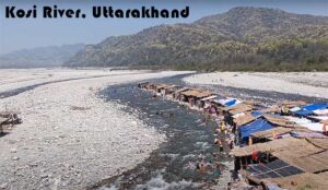
Continuing its journey, the Ramganga enters Rampur district, where it is joined by the Koshi River near Chamraul in Shahabad tehsil. It maintains its strong currents and southeastern direction as it flows through Rampur and into Bareilly district.
The Final Leg: Bareilly to the Ganges
In Bareilly district, the Ramganga receives the combined waters of the Bhakra and Kichha (also known as Baigul) from its left, and the Gagan River from its right. Near Bareilly city, it is further augmented by the Deoranian and Nakatiya rivers. The river continues its journey through Badaun, Shahjahanpur, and Hardoi districts before finally merging with the Ganges at Katri Chandapur village in Hardoi district.
Cultural Significance
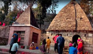
The Ramganga holds cultural importance for local communities. An annual fair is held on its banks in Chaubari village near Bareilly during Ganga Dussehra, typically in September or October, highlighting the river’s spiritual significance.
Conclusion
The Ramganga River, with its 373-mile journey from the Himalayan heights to the Gangetic plains, plays a crucial role in the geography, ecology, and economy of northern India. Its course through diverse landscapes – from narrow mountain valleys to wide alluvial plains – makes it a lifeline for agriculture, wildlife, and human settlements alike. As it merges with the Ganges, the Ramganga completes a remarkable journey that exemplifies the intricate river systems of the Indian subcontinent.
A Peaceful Escape by the Ramganga River in Marchula : My Memorable February 2024 Stay
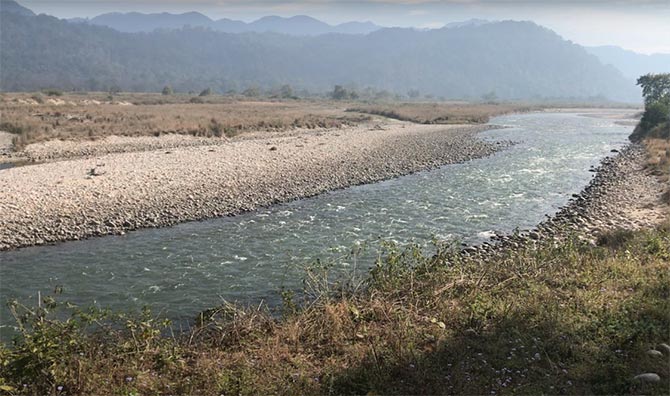
In February 2024, I had the privilege of staying in Marchula, a serene destination nestled near Jim Corbett National Park. Little did I know that this trip would gift me some of the most unforgettable moments of my life. What made it truly magical was the presence of the Ramganga River, flowing gracefully right next to our hotel.
Our hotel was perfectly located on the banks of the Ramganga River, giving us an uninterrupted view of its pure, crystal-clear waters. From our room’s balcony, we could see fish swimming right through the transparent river – it felt like nature had rolled out a private show just for us. The river wasn’t too high at that time, making it even more beautiful and calm. We even spent an afternoon fishing at the Ramganga, something I had never done before – the experience was peaceful and almost meditative.
If you’re a nature lover or someone who just wants to be near a soothing water body, Marchula is a great place to consider. There are several hotels and resorts dotted along the riverbanks, offering different perspectives of the river. A scenic road runs parallel to the river from Marchula to Bhikyasen, making it a perfect 10–15 km drive where you can enjoy uninterrupted views of the river while the Himalayan breeze plays through the trees.
I later learned that the Ramganga River originates from the southern slopes of Dudhatoli Hill, locally known as Diwali Khal, in the Chamoli district of Uttarakhand. It travels a long 596 km journey through valleys, plains, and lush agricultural lands before merging with the Ganges River at Katri Chandapur in Uttar Pradesh. Interestingly, it also flows right through the Jim Corbett National Park, making it an essential lifeline for the region’s wildlife and vegetation.
One of the river’s major highlights is the Kalagarh Dam, built for irrigation and hydroelectric power. Besides being essential for agriculture -especially in regions like Talla Giwar – the Ramganga also has cultural significance. For instance, a fair is held during Ganga Dussehra in Chaubari village near Bareilly, celebrating its divine essence.
Whether you’re looking for a peaceful retreat, a fishing trip, or a nature-inspired getaway, Ramganga River in Marchula will not disappoint. The tranquility, the natural beauty, and the warm hospitality of the local people made this trip a cherished memory. I can’t wait to return.